... The Flight Home
MORE 2011 EXPEDITION:
2011 Expedition Part 1: Fairbanks Alaska to Eureka Station
2011 Expedition Part 2: Eureka Station to Illinois
See the 2011 Polar Flight 90 Expedition Map
JULY 23, 2011
MACOMB, ILLINOIS TO OSHKOSH, WISCONSIN
|
|
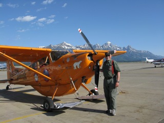
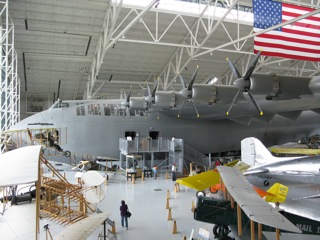
After the flight south from the Canadian High Arctic last May, the Polar Pumpkin has had a break - tucked away safely in the hangar. But it's now time to head out to the greatest general aviation event in the world - Airventure 2011. Besides putting the Pumpkin on display close to the center of the event, I'll be camping next to the airplane - and be giving 5 lectures. For anyone interested in aviation, Airventure should be on the list to attend - at least once.
The Polar Pumpkin, carrying its wheel skis, looked a bit out of place on the Macomb parking ramp - sweltering in the 100 degree heat. After repeatedly checking the weather between Macomb and Oshkosh, I found that there was a small break - a slot - between thunderstorms. These "Pillars of Power" are to be highly respected. As forecast, there was a good VFR route all the way.
Airventure personnel have Oshkosh Arrival Procedures well in place, in order to accommodate the thousands of aircraft inbound to the celebration. Flying, listening to radio instructions, and looking for other aircraft requires a pilot's complete concentration. Ideally, one would like to have a second or third set of eyeballs in the cockpit. But the Pumpkin and I arrived safely, landing on runway 18R, and were directed to parking.
AUGUST 1, 2011
OSHKOSH, WISCONSIN TO MACOMB, ILLINOIS
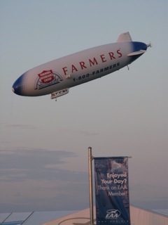 The Farmers' blimp doing aerobatics Oshkosh Airventure 2011 |
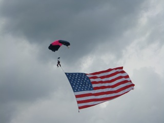 Patriotic Parachuting at Oshkosh Airventure 2011 |
As usual, Oshkosh Airventure proved to be a fabulous event - a great place to learn about specific aspects of aviation, stimulate new, and meet old friends from around America, and the world. Departing Oshkosh seems a bit easier than arriving. One receives a flight briefing from the onsite Flight Service Station, taxis into line, and departs - in my case runway 36L, left downwind departure to the south.
Visibility was marginal to good, with haze. Mind you, in Alaska we often - on clear dry days - have visibilities of 50 to 100 miles. On the way south, I decided to fly over a friend's rural property to get some aerial photos. In the Midwest, one must realize that aerial application crop dusters are low level; so one must maintain a safe altitude above them. Fortunately, I had good GPS coordinates - thankfully - since one cornfield looks like another cornfield!
Arrived Macomb all ok - with intentions to reload my Polar Gear, and head to points West, enroute home to Alaska.
AUGUST 3, 2011
MACOMB, ILLINOIS TO BEATRICE, NEBRASKA
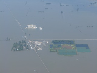 Terrible flooding devastation on the Missouri River 2011 |
Density altitude is a phenomenon with which all pilots must deal - especially in hot and humid environments such as the Midwest during summer. The air is less dense; and does not provide for optimum performance of aircraft. Therefore - to add just a bit more to the safety margin - I mailed a box or two of items back home to Alaska, that I would not need on the flight North.
One of the great aspects of flying in America is the multitude of airstrips - all shapes and sizes. On some of these - especially small grass strips - camping is an option; and, of course, I had all the camping gear on board the Polar Pumpkin that I need. My -40 sleeping bag was a bit excessive for the temperatures . . . but I managed.
After refueling, and bidding good-bye to my wonderful hosts at Cobb Aviation in Macomb, I headed West - and chose Beatrice, Nebraska for my next stop. Beatrice has a fabulous new passenger terminal, and - as is generally the case in the Midwest - many more fine folks. I look upon strangers as "friends that I just haven't met yet". An airport Courtesy Car was available for the ride downtown to some "mighty fine eaten".
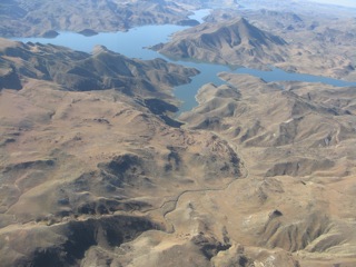
The most incredible sight on the way to Beatrice was the Missouri River. Due to a huge amount of snow in the Rocky Mountains over the winter - and full reservoirs along the Missouri (such as Fort Peck, Lake Sakakawea, Lake Oahe), there was nowhere for the water to go, but to flood the adjacent fields and towns along the river. Farmsteads, silos, fences, towns, and villages were engulfed by these flood waters. Emergency response teams were helping folks - such that I had to remain well high above this restricted airspace - but it was clear that many folks had lost everything. A sad sight, indeed.
One of the reasons that I chose Beatrice as a stopover is because a long time friend - from high school days - had been the Superintendent of Homestead National Monument, just outside Beatrice. This National Monument was established to interpret the historical significance and lifestyle of the early pioneers that came to this region to establish new lives, new farms, and - in some cases escape religious or economic persecution in countries from which they came. Although my friend no longer works at Homestead, I had a wonderful visit - maybe because I'm a farm kid at heart. "You can take the kid off the farm; but you can't take the farm out of the kid".
AUGUST 4, 2011
BEATRICE, NEBRASKA TO OGALLALA, NEBRASKA
It took awhile in the morning for the low clouds to break and lift. The ceiling was a bit ragged also. Nowadays, throughout the United States, there is a multitude of types of towers - radio, television, microwave, and perhaps predominantly the cell phone towers. Most of these are marked on flight charts; but, perhaps, some are not. I am not at all keen to get tangled in the guy wires of one of these; so I avoid any low level "scud running" - especially in this part of the world.
The flight across to Ogallala was uneventful. The terrain changed dramatically, however - from the rolling agricultural fields around Beatrice to more of a pasture ranching terrain around Ogallala. On landing there, I had a significant "shimmy" in the Pumpkin's tail wheel; so I had the local A&P mechanic make a repair.
True to form, folks were extremely friendly; and I was offered another courtesy car to go downtown for a nice steak supper at the Front Street Caf , and motel for the night.
Ogallala, on Interstate 80, is a town of approximately 4700 people located just south of the North Platte River - one of the main rivers running through the State of Nebraska. The town was a stop on the Pony Express trail, and a terminus of cattle drives to the Union Pacific Railroad, that arrived at Ogallala on May 24, 1867.
AUGUST 5, 2011
OGALLALA, NEBRASKA TO CHEYENNE, WYOMING
One of the challenges in piloting aircraft is to balance a multitude of variables; and try to pick the best - safest - combination. This morning, with mostly clear skies, I had the choice of taking off into the wind, down hill, but to the east , all ideal - but with the sun directly in my eyes. So I had the choice of waiting until the sun rose a bit further OR consider the compromise of taking off to the west - with the sun at my back - uphill (slightly) - and with a light tail wind. Considering the latter variables, and now with cooler temperatures, I chose to take off to the west - quite a normal and uneventful takeoff.
It was a fabulous morning. Besides the large expanses of cattle pastures, there was the occasional "pivot" circular irrigation installation. Over the years, I've done considerable business with Cabelas. I wanted to stop at their store and headquarters in Sidney, Nebraska; but the airport there was torn up for improvements, and closed for landing traffic. So I just flew by, with the town in the distance.
As I flew west, approaching the foothills of the Rocky Mountains, the terrain was rising. Cheyenne, the capital of Wyoming, is now a sizeable urban center, founded in the 1860s, and named for the American Indian Cheyenne nation - one of the most prominent and famous of the Great Plans Indian tribes. At the Cheyenne airport, the Wyoming Air National Guard bases a contingency of Hercules C-130 cargo aircraft. Since huge thunderstorms were brewing, I took the opportunity to put the Polar Pumpkin in a hangar for the night.
AUGUST 6, 2011
CHEYENNE, WYOMING TO ROCK SPRINGS, WYOMING
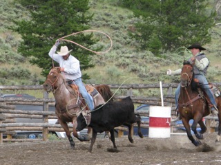 Team calf roping, Wyoming |
Another clear day, with the sun rising in the east, so I again took off to the west. Scattered about the prairie just west of Cheyenne was a "wind farm" - i.e. electric generators cranking out power from the prevalent wind of Western Wyoming. There are many of these - these days - throughout the windy parts of the America, including my home state of North Dakota.
After hopping over the Laramie Mountains - and the town of Laramie - I flew around the north end of the Medicine Bow Mountains. I had thought of landing at Rawlins to have a look around; but the winds were good, and I needed to put on more miles. So I kept on going to Rock Springs. So much fabulous wide open space. I could just imagine the wagon trains passing through this region in the 1800s, headed west go the gold fields of California, etc.
Besides the diverse landscape - rolling prairies, mountains, and forests - with an ample supply of wildlife, the region is rich in history. The town of Laramie - and many other features in the area, by the name of Laramie - were named after a French or French-Canadian trapper Jacques LaRamie that disappeared in the nearby mountains in the 1810s; and was never heard from again. Early in Laramie's history, lawlessness was a way of life: gun fights, hangings, robberies, etc. were commonplace. An early city official called the town "ungovernable". Many notable events occurred in one of the city's saloons - the "Bucket of Blood".
Rock Springs, a quiet airfield out in the countryside, provided an opportunity to stretch the legs, refuel, and have a snack.
One of the more infamous events of Rock Springs occurred on September 2, 1885 - the Rock Springs Massacre. This racial riot occurred between Chinese immigrant miners and white immigrant miners, brought on - at least partially - by the Chinese receiving a lower pay than the whites at the Union Pacific Railroad Coal Department.
AUGUST 6, 2011
ROCK SPRINGS, WYOMING TO PINEDALE, WYOMING
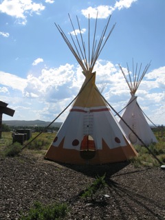 Teepees at the Museum of the Mountain Man - Pinedale, Wyoming |
In some parts of the American West - these days - the wide open rolling plains have, on the horizon, evidence of oil wells and associated paraphernalia. Southwest Wyoming is no exception. As I flew through clear skies, evidence of this development was ever so obvious.
In Alaska, one of the more popular bush airplanes is the Husky, manufactured in Afton, Wyoming. Afton was not so far off my course; but there just wasn't time to stop at all points of interest.
My friend John Douglas, manager of Emblem Aviation in Pinedale, met me at the airport, took me into town for a good meal, and loaned me his pickup to visit the Museum of the Mountain Man. More fabulous hospitality. The museum exhibits portray early life of Native Americans and fur traders such as Jim Bridger that trapped the valleys in the 1850s. In fact, the .40 caliber rifle, owned by Bridger, is on display at the museum.
AUGUST 7, 2011
PINEDALE, WYOMING TO JACKSON HOLE, WYOMING
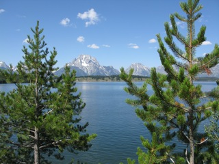 Teton Mountains, across Jackson Lake Wyoming |
Calm, sunny early mornings in the American West are just fabulous. It was such a pleasure to be cruising along with the Polar Pumpkin, enjoying the grand mountain scenery. Dropping down through the canyons, and into the basin with Jackson Hole, Moose, and Grand Teton National Park was great. Some of the haciendas on scattered promontories were "somewhat luxurious". Actor Harrison Ford - a pilot - is one of the celebrities that call the Jackson Hole area home.
The Jackson airfield is located a few miles north of town, up on an alluvial bench in the broad valley. On landing, and taxi to tie down, I wondered if I had landed at the appropriate airport - in that, as I taxied by the multitude of private jets, the humble Polar Pumpkin seemed a bit out of place.
My good friends Matt and Judy Montagne were there on the ramp to meet me. Matt is a pilot himself - and one of the talented artists of the valley. Matt's paintings grace the inside of the Jackson airport terminal building. He, Judy, and another well known artist - Mr. Greg McHuron - had visited our Peace of Selby Wilderness Lodge in Alaska's Brooks Range, during our watercolor painting workshop. At the National Museum of Wildlife Art - located just outside Jackson - there is the Greg McHuron Room, exhibiting some of Greg's work.
AUGUST 10, 2011
JACKSON HOLE, WYOMING TO IDAHO FALLS, IDAHO
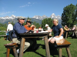 Matt, Josh, and Judy Montagne enjoying breakfast, Jackson Hole, Wyoming |
 Art with the Polar Pumpkin - Jackson Hole airport, Wyoming |
Teton Pass, a westerly route through the Teton Range, was my exit from the Snake River valley to the lower terrain of Southern Idaho. The pass itself is fairly narrow - and high - so after takeoff, I circled up to 10,000 feet to have a good safety margin going through the mountains.
Since I was headed west to some of the busier airports - such as Boise, Portland, and Seattle - I took the opportunity to have my Mode C transponder tended to at the FBO in Idaho Falls. Once again, lots of competent friendly folks.
AUGUST 10, 2011
IDAHO FALLS, IDAHO TO NAMPA, IDAHO
Later in the day - after my transponder was fixed - I once again headed west. Temperatures were starting to cool, after a fairly hot day. Still there were some dissipating cumulonimbus clouds. It was anything but a smooth ride.
Much of Southern Idaho is arid - sand and sagebrush. There are, however, areas where irrigation is an option. These "pivots", attached often to a deep water well or "bore", provided water to a set of elevated irrigation pipes on wheels, that tracked around the central pivot. When such arid land is irrigated, wonderful crops are produced. In this area, quality livestock hay was a typical commodity.
|
Arid ranching land of eastern Oregon |
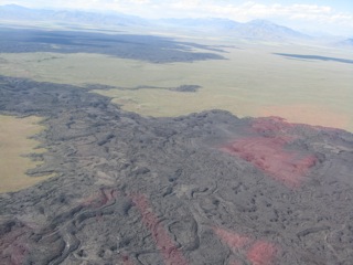
As a past National Park Ranger, I had heard of Craters of the Moon National Monument. It was an amazing sight - especially from the air - to see how the lava had oozed out of the ground and then solidified across the desert landscape. If I would have had an engine failure, there would have been absolutely no flat spot to make an emergency landing.
Even though Alaska is full of rugged mountains, I can only recall two proper ski areas - one just outside Fairbanks, and the other - Alyeska Ski Resort - just south of Anchorage at Girdwood. The Lower 48 States has a multitude of ski resorts, however; and my course west took me quite close to Sun Valley, Idaho. In the distance I could make out the silhouette of a Gulfstream private jet descending to the airport just south of Sun Valley.
Boise has a nice big airfield; but - being a country boy - I decided to fly just a bit farther west to the community of Nampa. There one can find a myriad of general aviation aircraft at this fabulous little airport. After getting the Polar Pumpkin parked, my friends Dick and Joey Stillinger arrived to take me to their house for the night. Dick has been a pathologist in the Boise hospital system for many years.
AUGUST 11, 2011
NAMPA, IDAHO TO BEND, OREGON
|
Craters of the Moon National Monument, Idaho - lava flows across the desert |
Forest fires in Alaska are a regular occurrence during the summer. Year to year, some summers are worse than others. Several years ago, over 6 million acres of bush burned. We're so fortunate to have fire control teams standing by - including the most amazing professional Smoke Jumpers. Since Boise, Idaho is the home of the Interagency Fire Center, I took the opportunity for a visit before hopping in the Pumpkin and heading west.
Being a "Country Boy" from North Dakota - growing up on a farm - I particularly enjoyed the aerial views of wide open prairie ranching country of Eastern Oregon. Much wide open space, interesting canyons, lakes, and rivers. One of the towns in the distance was Burns, Oregon - on the edge of the Harney Basin, and named after Scottish poet Robert Burns. How I wanted to stop there to meet local people and explore the lifestyle; but I had to keep going west. As I progressed west, the terrain changed from open grasslands to mixed terrain - i.e. the pine forest as well. I knew there would likely be elk, mule deer, bears, and coyotes in such habitat; but I wasn't so fortunate to see any.
Bend airfield was a busy place. I had the opportunity to visit the downtown area - spending time during the heat of the day - and later in the afternoon, got ready for my flight over the Cascade Mountains to Independence, Oregon.
AUGUST 11, 2011
BEND, OREGON TO INDEPENDENCE, OREGON
|
|
The trees are so much bigger in Western Oregon than the trees in Arctic Alaska. I could see scars in the forest - much like that in Alaska - that signified forest fires and/or logging operations.
As I fly along, I try to keep emergency landing locations in mind. There were areas, however, over these mountains and big timber, that finding a graceful landing location would have been difficult. Then, to find a downed aircraft in the big timber, I would think, could be nearly impossible at times.
As I left the mountains, the Willamette River valley opened up to some incredibly rich agricultural land. A myriad of crops are grown. Listening on the radio, I could tell there were lots of airfields in the area.
My brother-in-law Curt Richmond met me at the Independence Airport. The Polar Pumpkin was given an oil change and put away in the hangar - to take a break from traveling - as I headed back to Alaska with the airlines to care for guests at our Peace of Selby Wilderness Lodge.
OCTOBER 27, 2011
INDEPENDENCE, OREGON TO PORT TOWNSEND, WASHINGTON
The summer rolled by all too fast. Fall arrived; and it's time to get the Polar Pumpkin back to Alaska before winter.
The valley between the Cascade Mountains and the Coastal Range is a natural corridor for the flight north to the Seattle area. I chose the small airfield at Port Townsend; since my friend Eric Sterling lives in the area - and because it was outside the busy airspace of the greater Seattle area.
Today's weather was generally good; but with some haze and occasional scattered cloud. One of the main rivers that I crossed was the mighty Columbia - the headwaters of which run through much of Washington, and a portion of which forms the border between Washington and Oregon. Channels in the lower river allow ships of various sorts to travel from the Pacific Ocean to the port of Portland, Oregon. My course took me over the town of Centralia, Washington. Dave Zucatti, a friend from the Antarctic, lives there. Years ago, we worked together near the Polish Antarctic base of Arctowski.; where our assigned task was to build a small ornithological hut for scientists. The beach - which was nicknamed the "Copacabana of the Antarctic" - in front of the hut, was teaming with wildlife - including fur seals, elephant seals, and penguins of various species. Across Admiralty Bay was the Brazilian scientific station of Ferraz - a fabulous location, with fabulous people, with whom we were able to celebrate the first Antarctic "Carnival".
Port Townsend is considered one of the best examples of a Victorian seaport in the United States. It was named by Captain George Vancouver in 1792. The area was inhabited by a variety of native tribes; and the city was officially formed on the 24th of April 1851. Many Victorian structures still stand today, with a myriad of hotels, restaurants, book stores, and galleries.
OCTOBER 31, 2011
PORT TOWNSEND, WASHINGTON TO ARLINGTON, WASHINGTON
After a few days of errands in the Seattle area - including visits to the Pacific Marine Environmental Lab, giving a lecture at the Pacific Northwest Chapter of The Explorers Club, and - of course - a visit to Ivar's Fish House for a delicious batch of Puget Sound oysters - I flew the Polar Pumpkin a short distance east to Arlington. Explorers Club Program Chairman, Ron Zuber, was particularly hospitable during my visit - for which I'm very grateful.
The greater Seattle area has a variety of airspace, with some Restricted Areas, for Naval Aviation jet training, etc. Since I was more used to the wide open space of the Brooks Range, I was particularly careful to stay well clear of these restricted zones.
Although Airventure in Wisconsin is one of the largest general aviation air shows in the America, another show held every year at Arlington, Washington is also significant. I've not had the pleasure to attend; but I could see that there would be ample space on the airport grounds for such an event. Shortly after I got the Pumpkin tied down, I was able to enjoy watching glider towing in the evening.
NOVEMBER 1, 2011
ARLINGTON, WASHINGTON TO WENATCHEE, WASHINGTON
Fall time weather in the Puget Sound vicinity often consists of fog, rain, and low ceilings. Realizing that the weather would be generally less rainy on the eastern side of the Cascades, I took off for Wenatchee - through Stevens Pass - at the first weather opportunity.
Wenatchee, located at the confluence of the Wenatchee and Columbia Rivers, was named after the Wenatchi Indians. Clovis points can be found in the vicinity; and evidence of the earliest natives dates back 11,000 years. Fur traders and trappers entered the region in the early 1800s - missionaries soon thereafter - and the city was officially incorporated on January 7, 1893. Wenatchee is now called the "Apple Capital of the World" - with numerous orchards of other fruit species, as well. I had a "hankering" for a jug of apple cider - which was readily available from numerous roadside fruit stands.
The Wenatchee airport is located up on a bench - actually in East Wenatchee - and the hills nearby was the site where Clyde Pangborn and Hugh Herndon belly landed their aircraft "Miss Veedol" on October 5, 1931 after a 41 hour flight from Sabishiro Beach, Japan. They had taken off on a wheeled undercarriage; but dropped this apparatus when airborne, in order to increase their speed for the long flight across the Pacific. This flight won them the Harmon Trophy for flight for the year 1931. An incredible achievement.
NOVEMBER 4, 2011
WENATCHEE, WASHINGTON TO OROVILLE, WASHINGTON
My course north from Wenatchee took me past other Washington cities such as Chelan, Okanagan, Omak, Tonasket, and on to the small community of Oroville. Friends of mine had been fruit farmers in Oroville for awhile; but decided to move back to the bush of Alaska.
The Oroville airport manager - a particularly friendly gentleman - came by the Pumpkin, as I was preparing the airplane with wing covers and engine cover for the night. Frost was expected. Soon a van arrived, driven by the proprietress of the local motel, and off we went to downtown Oroville. I had the choice of two restaurants for supper - each offering home cooked cuisine, served by friendly folks. I do enjoy meeting folks, and learning about their diverse backgrounds, throughout America - and the World.
Oroville was first settled by Caucasians in the 1850s. Oro - being the Spanish word for gold - implies the numerous gold mines in the vicinity during the 1890s.
Since Oroville is only 4 miles south of Canadian border, it was the likely spot to prepare for crossing into Canada - and submitting the proper EAPIS material required by the U.S. Customs and Border Protection. All information must be submitted online - only. This system produces a distinct pain in the posterior of most pilots with whom I've spoken.
Canadian Customs and Immigration must, of course, also be notified; but the basic Canadian policy for transit of small aircraft through their country seems to be: Welcome, have a nice trip. Canadians - indeed, America's best neighbors.
NOVEMBER 5, 2011
OROVILLE, WASHINGTON TO KELOWNA, BRITISH COLUMBIA
On course through the Okanagan Valley put me just east of the fabulous Penticton Airport. Since the cloud layer was a bit low, I flew over the beautiful Okanagan Lake, avoiding the higher terrain to the east.
The Okanagan Valley is named after the Okanagan people, an Interior Salish people, who were primarily hunters and gatherers that followed the salmon runs, harvested game, and utilized the berries and roots in the area. The native Okanagan people nowadays, however, comprise a sovereign nation and live from a natural resource/tourism based economy.
The air traffic at the Kelowna Airport was fairly busy when I arrived; but all was fine. Canadian Customs met me on schedule; and, per normal, politely cleared me and the Polar Pumpkin for transit through Canada back home to Alaska.
Weather to the north was good - and improving - so I decided to press on.
NOVEMBER 5, 2011
KELOWNA, BRITISH COLUMBIA TO PRINCE GEORGE, BRITISH COLUMBIA
After takeoff from Kelowna, I climbed over some higher terrain - amid a scattered undercast - with the idea of next stopping at Williams Lake. This course took me just to the east of Kamloops, British Columbia. The name Kamloops is a derivation of the Shuswap Indian word meaning "meeting of the waters" - in that the city is located at the junction of two branches of the Thompson River and Kamloops Lake.
As I flew along to the northwest, the weather did in fact improve as forecast. Therefore, even though it would have been fun to stop in Williams Lake, I took advantage of the clear skis; and proceeded on to Prince George - arriving there not so much before dark.
Williams Lake, named after an Indian Chief William, was established as a supply center during the first gold rush and fur trade eras of the 1800s. One of the big events of the year is the Williams Lake Stampede, held over Canada Day; which includes a parade, exhibits, and a fabulous rodeo - featuring bull riding, barrel racing, bareback bronc riding, steer wrestling, and chuckwagon rides. On the next weekend after the Williams Lake Stampede, the famous Calgary Stampede begins - with many of the same activities. Both rodeos feature international competitors.
Williams Lake is home to Mr. Rick Hansen, a well known Canadian paraplegic athlete and activist for spinal chord injuries. Mr. Hansen is perhaps most famous for his fund raising "Man in Motion" world tour.
NOVEMBER 8, 2011
PRINCE GEORGE, BRITISH COLUMBIA TO FORT ST. JOHN, BRITISH COLUMBIA
I was fortunate to get to Prince George when I did; because, overnight, the weather turned dismal - with wind, snow, fog, etc. This condition gave me a two day opportunity to learn a few things about the area; and, once again, meet many more fine folks.
Prince George is the largest city in Northern British Columbia, with a population of approximately 71,000 - located at the confluence of the Fraser and Nechako Rivers. The settlement first originated as a fur trading post called Fort George in 1807, established by Simon Fraser in honor of King George III. Nowadays the economy consists of pulp mills, oil development, the University of Northern British Columbia, and many other industries.
Due to the snow and ice storms of the past couple days, I had to have the glycol de-icing truck come by the Polar Pumpkin before I could take off. When I did get going, the low cloud and light snow made visibilities marginal north to the community of Mackenzie, British Columbia.
Mackenzie is located at the south end of Williston Lake. The flight route north across Williston Lake on up to Watson Lake is often called "The Trench"; since it's a relatively narrow valley with high mountains on both sides. I've flown the route in the past; but with marginal weather - and very few emergency landing strips - I decided to "hang a right" from Mackenzie and go to Fort St. John. Since clouds were obscuring the mountains; I had to climb up to 10,000 feet enroute to Fort St. John. I had a good tail wind; and Fort St. John was in the clear.
Fort St. John was established as a trading post in 1794; and was a key location for the construction of the Alaska Highway, that was completed in 1942. The 19,000 people living in this majestic Peace River Country denote their community as being the "Oil and Gas Capital" of British Columbia. Oil was discovered there in 1951.
NOVEMBER 8, 2011
FORT ST. JOHN, BRITISH COLUMBIA TO FORT NELSON, BRITISH COLUMBIA
After a brief refueling stop in Fort St. John - and a sandwich with my coffee - I once again decided to take advantage of the good weather; and fly on up to Fort Nelson. The terrain along the route was relatively flat - with patches of cleared areas (homesteads?) and oil exploration seismic lines in the bush. It looked as though there would be lots of moose in the area; but I was a bit too high to spot any.
My friends at Sky North found a good spot to park the Polar Pumpkin; and off I went from the airport to my motel in Fort Nelson. Little did I know just how bad the weather was to be, grounding me for the next 5 days. Jill and Jordee looked after me in grand fashion there in the pilot's lounge of Sky North. Never in my wildest imagination would I have expected to be served delicious portions of bacon and eggs, chicken kiev, etc. Hospitality at its finest!
After waiting the first couple days, I tried to get through to the north; but weather was just too bad - fog to the ground. I made it out about 40 miles; and had no choice but to return to Fort Nelson.
The city of Fort Nelson is located at the confluence of the Fort Nelson River, Muskwa River, and Prophet River. About 5,000 people live there - at 300 mile on the Alaska Highway - and the economy is based mostly on energy and tourism. The community was first founded as a trading post in 1805, established by the Northwest Company - and named in honor of Horatio Nelson. The airfield was built in 1941, as part of the World War II Northwest Air Staging Route.
NOVEMBER 14, 2011
FORT NELSON, BRITISH COLUMBIA TO WATSON LAKE, YUKON TERRITORY
From Fort Nelson to Watson Lake, one has the choice to follow the route of the Alaska Highway, or take a more direct route over lower terrain. In the latter case, however, emergency landing options are few to non existent. Weather in the mountains was still poor; so I decided to head north to the mouth of the Toad River. From there I followed the Liard River; and then to Watson Lake along the Alaska Highway.
The weather enroute was a mixture of snow squalls and scattered low cloud/fog. Although the Polar Pumpkin was fitted on skis, the option of making emergency landings on frozen lakes and rivers was poor. The ice was yet not thick enough to support such weight. Actually the Toad and Liard Rivers both still had pans of drifting ice.
The best emergency landing strip of all was the Alaska Highway. Canadian road crews have straightened and groomed the highway, such that's as good or better than some airstrips. Not far from Liard Hog Springs is an airstrip that was constructed during the 1940s. I had landed there on other flights through the area; but presently, it appeared that willows had grown up to now make the airstrip unusable. Had I more time - and better weather - I would have considered landing on the road to go for a nice soak in the Liard Hot Springs.
Arrival and refueling in Watson Lake was fine. After plugging in the airplane, I pulled food out of the airplane; and set up for an overnight in the pilot's lounge. The weather reporting and radio service was open 24 hours; so I had ample opportunity to visit with the operators - and learn a few things about the local area.
In 1897, a young 14 year old lad Frank Watson headed north with his father from their home in California, to find their fortunes in the gold fields of the Canadian Klondike. Six years later - in 1903 - Frank Watson, a prospector and trapper, was traveling overland through the Upper Liard country (the first white man to do so); and settled on what was first called Fish Lake. The lake was later named Watson Lake.
The actual settlement of Watson Lake didn't blossom until the construction of the Alaska Highway (milepost 635) and the Watson Lake airport in the early 1940s. There are now only approximately 1500 people that live there; depending on resources from forestry and mining (asbestos and tungsten) - along with subsistence resources of hunting, fishing, and trapping. One of the more famous features of the community is the "Signpost Forest". Back in 1942, a homesick U.S. Army GI put up a sign from his hometown; and, since then, approximately 76,000 other signs have been put up.
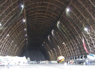
The airfield is indeed "pilot friendly", by providing a well kept camping location and convenient access to pilot services. One of the original World War II hangars is still standing.
NOVEMBER 15, 2011
WATSON LAKE, YUKON TERRITORY TO WHITEHORSE, YUKON TERRITORY
One of the great aspects of general aviation is the camaraderie among pilots. Since there were still snow squalls in the area, I stayed on the ground; and first queried the pilot of a Bell 206 helicopter that had come through from Whitehorse. Also, a flight crew flying a Royal Canadian Mounted Police Pilatus PC-12 also provided valuable information. The helicopter report was for very bad weather over the mountains direct to Whitehorse; so I then decided to follow the Alaska Highway.
The folks at Walkers Continental Divide Lodge were particularly helpful - by phone - with a report that the weather was lifting there. So off I went - with generally good visibility. Teslin Lake - being yet mostly wide open water - produced a layer of low cloud and fog. But staying above this broken undercast provided good visibility all the way to Whitehorse. Days are short this time of year; so I arrived Whitehorse none too soon, before dark.
Once I had the Polar Pumpkin tied down at the base of the Tower, I had only a short walk from the airport across the Alaska Highway to motel accommodation and a good supper.
Whitehorse is the capital and largest city of the Yukon Territory - with approximately 26,000 inhabitants. The city was named after White Horse Rapids - for their resemblance to the mane of a white horse near Miles Canyon, before the river was dammed. One of the most well known dogsled races in the Far North - the Yukon Quest - is run between Fairbanks, Alaska and Whitehorse during early February each year.
NOVEMBER 17, 2011
WHITEHORSE, YUKON TERRITORY TO DAWSON CITY, YUKON TERRITORY
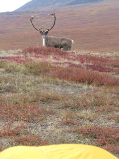 A nice bull caribou 20 yards from Art's tent in the northern Brooks Range |
There was no question what to do on November 16 - stay on the ground. Snow, wind, and poor visibility made flying the Pumpkin impossible. So . . . it was a good day to catch up on correspondence, visit with flight service station, and check the overall weather map. The Whitehorse flight service staff has always been particularly helpful. The sad news is, however, that plans are in motion for closing the local station; and then consolidate briefing information to a larger city. Too bad. I'm for using local knowledge as much as possible.
Although this morning's weather was still poor, the forecast was for improvement. The forecast, however, did mention the possibility of moderate to severe turbulence in the St. Elias Mountains. Since I got hammered by severe turbulence in the Kluane Lake area on a previous trip, I decided to head northeast to Dawson City, Yukon Territory - thereby getting further away from the taller mountains, and turbulence.
The road to Dawson from Whitehorse parallels the Yukon River for a portion of the way . . . more or less . . . via Carmacks; but then heads away from the Yukon, at Minto, to the north and east, via Pelly Crossing. Both the river and the road were my "navigational aids" in numerous snow showers, restricting visibility. Where the road left the river, I decided to follow the road; since the Yukon was still running ice pans, and an emergency landing there would have been impossible. Even when I hit the Klondike River, snow squalls were prevalent; so I followed the Klondike right in to the Dawson airport - which is located a few miles east of Dawson City.
For the history buff, Dawson City and the Klondike are a "gold mine" of information, so to speak. Gold was first discovered on the Klondike River by George Carmack in 1896. The Gold "Rush" began the next year - 1897 - and continued heavily through 1898, until the next major find occurred in Nome, Alaska. The attempt to "strike it rich" was made by an estimated 100,000 people, from all walks of life. There were 3 primary routes to the Klondike - a. an all Canada overland route b. Via Skagway, Alaska and the Chilkoot/White Passes c. Via St. Michael, Alaska at the mouth of the Yukon and by paddle steamer upstream to Dawson. Years ago, I had the pleasure of working as a National Park Ranger at the Klondike Goldrush National Historical Park on the Chilkoot Trail. It's amazing how much gear is still evident along the trail. Many tons of gear were packed up and over the Pass, and on downstream from Lake Bennett to the gold fields.
From the discovery of Klondike gold in 1896 to the year 2005, approximately 1,250,000 POUNDS of gold had been extracted from the region. At the current price - say $1800 per ounce - that amount of gold would equate to "quite a sizable sum".
NOVEMBER 18, 2011
WHITEHORSE, YUKON TERRITORY TO FAIRBANKS, ALASKA
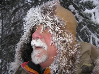 Art on a cold winter day |
Although it was a bit chilly - thirty to forty below zero - visibility was excellent the entire route to Fairbanks. After a good breakfast of bacon and eggs at the hotel, the Polar Pumpkin and I headed out.
My course put me over the rugged rolling hills south of the Alaska Yukon Charlie National Preserve. On many of the creeks, one could still see evidence of placer gold mining. The airstrip at Chicken, Alaska was inviting; but I had a Customs agent to meet, with no time to stop. The community of Chicken - based on gold mining - had a population of 7 people at the 2010 census. Gold was also discovered there in the late 1800s; and a post office established in 1902. As the story goes - since "ptarmigan" may be such a hard work to pronounce - and there were many of these grouse in the area, folks decided it would be better to just call the town "Chicken".
One of the first "Alaska Books" that I read, years ago, was entitled "Tisha" - about a woman Anne Hobbs Purdy, and her life as a teacher in Chicken, for one year in the late 1920s. An absolutely excellent book.
Arrival at the Fairbanks International Airport - on Runway 20R - was uneventful; as was my clearance with U.S. Customs and Border Protection. I had filed my EAPIS information online from Dawson. I'm always particularly appreciative of agents that can conduct their duties efficiently, respectfully, and politely.
It was good to be back in "home territory", after a wonderful flight through Arctic Canada - nearly to the North Pole - a good portion of the USA "Lower 48", and back home to Alaska through Western Canada.
Since leaving Fairbanks on April 3, 2011 and returning on November 18, 2011, the Polar Pumpkin and I had flown over 9,000 miles.
Now . . . it's time to get ready for our second attempt on the North Pole, during April 2012.